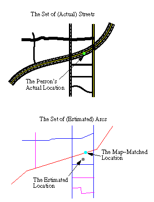
A number of different radio/satellite positioning system can be used to determine a vehicle's location (e.g., GPS). For many applications (e.g., providing route guidance, using vehicles as probes) this location must be matched to a particular street. This is illustrated below:
When both the user's location and the underlying network are very accurate, the reconciliation problem is thought to be straightforward - simply "snap" the location obtained from the GPS receiver to the nearest node or arc in the network. Hence, it is not surprising that a number of people are working on improving the accuracy of both the underlying network and the positioning system.
However, in many situations it is either not possible or not desirable to improve the accuracy of the map/network and the user's location enough to make a simple "snapping" algorithm feasible. Hence, the purpose of this research is to explore map-matching algorithms that can be used to reconcile inaccurate locational data with an inaccurate map/network.
The following map matching resources are currently available on this site:
For information about this project, feel free to contact the relevant faculty/students directly.